Malmö
Malmö.
Landscapes in transition
AREA OF RESEARCH
Municipal territory of Malmö
PHOTOS
Alessandro Guida
TEXTS
Viviana Rubbo
YEAR
2022
FOR
Malmö University (MAU)
Institute for Urban Research (IUR)
EXHIBITION
29.04.2022 - 29.05.2022
University of Malmö
Niagara Building
The Exhibition was curated by
Alessandro Guida and Viviana Rubbo
A heartfelt thank you to:
Guy Baeten (Director IUR) and Adriana De la Peña Espinosa (Research assistant at IUR) for supporting our work throughout the residence.
A special thanks to:
Magnus Denker (Artistic Lecturer at MAU) for assisting us and making possible the exhibition.
And, for having dedicated their time to write, talk or meet with us, to:
Peter Parker (Senior lecturer, Master Urban Studies), Karin Grundström (Associate professor in Architecture, Urban Studies), Martin Grander (Lecturer and researcher, Urban Studies), Amanda Fröler (Architect, Malmö City Planning Office), Hanna Björklund (Project manager comprehensive Plan for Malmö), Gustav Aulin (Urban planner, comprehensive Plan for Malmö), Ulrika Geeraedts (Director of Regional Development, Region Skåne), Richard Gullstrand (Regional Development, Region Skåne), Anna Seravalli (Senior Lecturer and Researcher in Design, MAU) Marcus Horning (Director Malmö City Planning Office), Finn Williams (City Architect, Malmö Stad), Joakim Nordqvist (Climate Strategist, Malmö Environmental Office), Philip Tanimura (Malmö City Planning Office)
During the artist in residence at the University of Malmö, Paesaggisensibili has developed a photographic project that involved researchers and local actors for a critical reflection on the changes that have shaped the landscape of the city over a span of few decades, focusing on the outermost areas of the territory bordered by the infrastructural system of the rings.
Geographically compact, socially and economically segregated, small in size, young, dynamic and global (183 nationalities and half the population under 35), Malmö is a city of contrasts and records, for the better or for the worse.
After the dark years of the industrial collapse, the city was reborn under the banner of creativity and research-driven innovation in a vision of development which placed the city in the international scene. With the new millennium, first the tunnel, then the bridge making the connection to Copenhagen, the new university center and the transformation of the westernmost portion of the port (Vastra Hamnen), gave way to a profound metamorphosis that has rapidly changed its face.
The city welcomes many start-ups and young businesses, growing prominently by over 3,000 units every year. For over twenty years, in line with this trend, it has continued to expand, building houses, offices and new industrial sectors, as if struck by what looks like urbanization bulimia. Despite all this, the city remains the urban area with one of the highest unemployment rates in all Sweden, highlighting the need for complex responses to address a contemporary urban society that has changed radically, and perhaps, too suddenly.
This photographic research was an opportunity to explore the weft of this composite and complex urban pattern with a journey through the many places that are many stories, many characters as well as many identities, all part of the same organism, today more than ever, in search of itself.
The development programs for the next twenty years are impressive and foresee the transformation of large urban portions inherited from the industrial period that ended around the 1980s. A piece of this history can be appreciated in the Kierseberg district: striking and overwhelming red-brick industrial structures have been preserved and temporarily readapted to the cultural and creative industry functions. The same materials and forms molded the village around it. Unlike the rest of the city, here the urban landscape is marked by the small scale of the buildings, shops on the ground-floor, spots where the community meet. Tiny brick and colorful streets houses make the district a world on its own: it is the “we, of the Kirseberg hills”, the story of a neighborhood born in the early twentieth century.
In other areas, the space left by the industrial production has offered new spaces for immigrant entrepreneurship and cultural activities. The current dynamics see the conversion of these spaces into residential areas accelerating the gentrification process already underway, especially in those sites which are closer to the center. But the city does not grow only on itself, transforming the existing spaces; on the contrary, it moves forward, stepping on the rural land and greenfield areas around it, raising controversial questions and dilemma: a growing urban core, increasing demand on housing, jobs, and urban services versus agricultural exploitation – one of the most fertile lands in Europe – and nature and biodiversity protection and conservation. The result so far is the creation of new settlements such as the international district of Hyllie, strategically located west on the exit of the Öresund bridge.
Among these opposite poles, the landscape is marked by the public housing districts that have materialized the national housing programs over the years 1960s and 1970s. Silent, still, crystallized, embedded today in the urban grid, those blocks, though aged prematurely in the physical structures, might look the same: yet new and different life and societal changes unfold.
EXHIBITION AND PUBLIC DEBATE
The outcome of this work has become a public exhibition hosted in the University’s spaces and used by the City’s Planning department to involve citizens in a critical, open, and participatory discussion.
A representation of the urban landscape’s transformation that aims to provide an overview and, at the same time, an opportunity to steer a collective reflection on the contemporary city.
INTERACTION WITH THE EXHIBITION
The exhibition was designed as work boards. The images, as tools of reflection on the changing city. Visitors were invited to use post-it and pencil and let the exhibition space become a board for discussion. There was also a QRcode which allowed the visitors to send messages online. The observations were collected and sent to the city of Malmö for a collective reflection.


explorations in Malmö
Landscapes in transition
A new narrative for Malmö
Old house near a new development in Tygelsjö
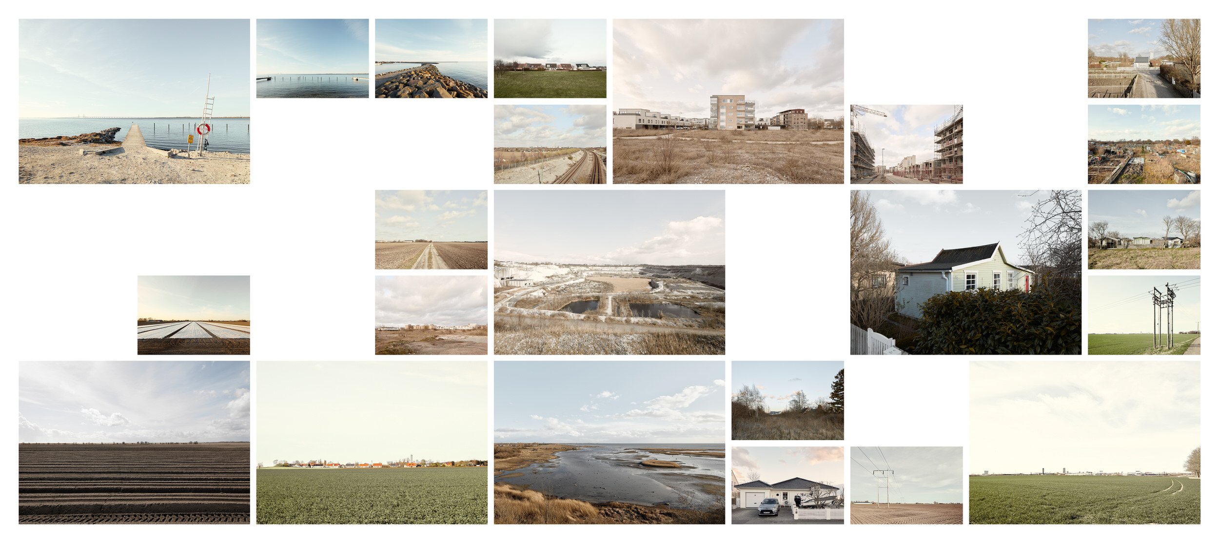
Our journey started by the seashore on the west coast.
The coastline let appear the industrial memories which include abandoned quarries, docks, and dumps. They have all become sanctuaries of nature protection. Klagshamnsudden, a strip of land that was built during the construction of a small quarry to produce cement, and not far away, another crater, the legacy of an impressive mining activity that spanned over the twentieth century. Production closed in Limhamns Kalkbrott in 1994 and nature returned occupying the empty cavity and turned it into an oasis of protection for endangered species. Today the steep walls of the quarry protect the new ecosystem and force the urban sprawl to a halt. Along the edges, on each side, there are new construction. The city is pressing on the borders and does not seem to give up.
The rural countryside is just a few steps away. The best fertile soil in Europe is there and counts the meters from the next construction site.
Summerhouses and vegetable gardens preempt the city. They occupy the residual spaces along the traffic routes, on the edges of the rings and of the highways’ connection roads.
The new Hyllie, the international district which is being built next to the bridge and connecting the city with Copenhagen airport
Before us, the new district of Hyllie.
The international center was born as an extension of Copenhagen airport, an ongoing construction site located onto the rings’ system at the exit of the bridge. Shopping area, intermodal exchange platforms, hotels, and residential buildings: a dense, dry, immaculate place, absence of greenery, concrete. This is a landscape that thickens by superimposing the landmarks of yesterday and today in the new city’s skyline.
Clear and sterile context, variations of semiprivate spaces: urban rooms, sudden contrasts between density and emptiness that open windows onto the countryside.
More construction sites are not far away. Densification doesn’t happen in the urban center only but affects as well the small villages such as Tygelsjö, one of the many little towns scattered in the rural areas surrounding the municipality of Malmö.
The farmland around the city, one among the most fertile soils in Europe
The countryside is characterized by intensive agriculture, numerous greenhouses, and water collection tanks for irrigation purposes.
We are back on the edge of the outer ring. Vacation homes become spaces of informality and expression of colorful and exotic dreams. Unexpected places with small gardens and hidden passages. Spontaneous world.
And just beyond the wall of so much vagueness, a commercial platform materializes. Huge parking lots, large surfaces of asphalt, the commercial square is a parenthesis floating between the city and the countryside. Junctions, roundabouts, and the intertwining of streets bring back to the order of the residential districts. Lindeborg and then Lindängen: each step is a progression through different worlds which get closer yet remain distant.
We are at a new junction. The fast-food towers are bulwarks of conquest of our globalized world. In the space between Yttre Fosie and Jägersro density become looser, and the urbanization pattern let in large meadows, woods, and agricultural lands.
The track of a railway line emerges, and nearby mounds of earth herald something new on the way.
A lonesome mosque stands alone emerging from the bare earth. In the distance, the noises of the rides that animate the night of Jägersro; the footprints of a horse launched at a gallop and the sign of water, an oasis of peace and nature protection reminds us of the origin of this place.
A lonely mosque near the motorway network where new construction sites have begun.
Looking north just beyond the inner ring, we enter a new dimension. Rosengård is one of the many neighborhoods of the Million Program created by the Swedish government between 1965 and 1974 to guarantee everyone access to a good quality home at a reasonable price. Many of these large housing estates are locates on the two sides of the inner ring; they have marked the housing policy programs from the 60-70s onwards. Become part of the urban grid today, at a first sight they appear frozen in time, crystallized; aged prematurely in the physical structures, yet accommodate new and diverse in the population which changes over time. Details emerge and tell a more complex story, a life that unfolds behind the windows, in the public space where new businesses have settled over time. Green spaces are overwhelming and stretch as far as the eye can see.
So tall and imposing, the large blocks dominate the landscape beyond the barrier of the inner ring. Beyond the residential area, one enters an unusual and surprising animated milieu, where many of the city's industrial structures have been converted into small commercial businesses and cultural spaces incorporated into the urban fabric.
One of the many large housing estates created through the State run Million Housing Program during the 60s and 70s of the XX century on what were, at that time, the edges of the city.
The Million Housing Programme estates as they appear: green land as far as the eye can see, only pedestrian and cycle paths, uniformity and order
While modifying its assets, urban values and vocations, the urban pattern of the city has evolved. The development programs for the next twenty years are impressive and foresee an acceleration in the transformation of some of these inner portions of the city which represent the legacy of the industrial period. They have often become the ideal location for the creative and cultural industry, for young startups, spaces for the immigrant communities and the new generations of entrepreneurs, yet the renewal process put in motion is hastening the gentrification process. But the city’s growth has also speeded up the creation of new residential settlements and new commercial centers and spaces for businesses between the two rings, intensifying the occupation of agricultural land.
A former industrial warehouse converted into a gym for circus activities
Following the path of our journey along the ring roads, it is again uncertainty of a landscape in transition towards new uses. Lonely agricultural areas abandoned greenhouses and warehouses for new distribution companies. More building sites in an area that is subject to an industrial development plan. We cross the edge of the city’s border and end in Burlov: trellis of a large electric power plant and a golf course and then back to Sege Park. Again, another large construction site where historical buildings are refurbished, and new developments embedded to experiment a new way to conceive a mixed urban district where shared services and facilities are combined with new housing provisions addressing different needs.
Grand Circus Hotel. Informal uses in one of the portions of the former Lockstallarna industrial area in Kirseberg district.
Treading the meadows on the edge with Burlöv, suddenly a trace of the railway track emerges from the ground and the industrial memory of the city materializes. We decide to follow it and arrive in Kirseberg.
We approach the neighbourhood from the abandoned track which is quite popular among the locals for relaxing walks. Across a gate in the fence, we enter Lockstallarna: this is where a century ago the production of trains’ engines and wagons began. Impressive and overwhelming red-brick industrial structures have been preserved. The same materials and forms molded the village around it. Unlike the rest of the city, here to mark the urban landscape is the small scale of the buildings, shops on the ground-floor, places where the community meet. A peculiar atmosphere, a mix which makes this place different and unique compared to what we have seen along the way.
Urban forms of Kirseberg district born around the locomotive industry at the beginning of the twentieth century.
Tiny brick and colorful street houses make the district a world on its own: it is the "we, of the Kirseberg hills", the story of a neighborhood born in the early twentieth century.
A consolidated space, with a history, and a dense architectural identity. Yet, this is also a place which seems on hold. Suspended, uncertain state between past and future. In the next few years, a massive new development is expected to bring into the district houses, working places and urban facilities questioning the relationship with the existing urban tissue and the integrated vision of the city as an organic system.
But today the district is isolated like an island emerging from the urban space around it. In recent times cultural activities and the creative industries have reconquered this area reinventing it. Informality brought new meanings, while nature took over on this uncertain condition: just over the railway edge, birch trees bend their arms on still waters between the warehouses.
Nyhamnen: this is Malmö's industrial shipping sector of the harbor which will be transformed over the next 20 years and become home for 25,000 new residents. Over the past decades, Malmö has grown by 3,000 units per year.
Seeking the sea we land once again on the coast. We move between Spillepengen and Frihamnen. There is no other way than approach the water from the large industrial port. This is where in the next fifteen years huge redevelopment plans will be carried out.
We have moved in semi-circle around the edges of the municipal borders, and we end our journey where the city meet the sea: the industrial harbor.
The outcome of this work has become a public exhibition hosted in the university's spaces and used by the City's Planning Department to involve the citizens in a critical, open, and participatory discussion.
A representation of the urban landscape’s transformation that aims to provide an overview and, at the same time, an opportunity, to steer a collective reflection on the contemporary city.